
I think a lot of folks who live outside of Texas tend to forget that Texas is on the U.S.'s third coast. It has one. A long one, nearly as long as Florida's Gulf Coast. (Texas just doesn't have a coast on the other side, like Florida's Atlantic coast.)
The countryside along the Texas coast, from the Sabine River on the Louisiana border to the Rio Grande on the border with Mexico, is pretty much the same. It's flat, swampy and bordered with barrier islands or peninsulas. Just north of Galveston Island is Bolivar Peninsula. South of Galveston is Surfside, a beach community on another peninsula, I think. Bolivar is in Galveston County, and the most direct route to Beaumont and Louisiana. Surfside is in Brazoria County, so I don't know as much about it, but it's where we went to the beach when I was in high school in Houston back in the early '70s.
 |
| The Texas coast from space |
Corpus Christi Bay is a deep bay. There's a Navy base there, with ships and everything. The Houston Ship Channel runs through Galveston Bay. Ships line up in the Gulf waiting for a pilot to take them through Bolivar Pass between Galveston Island and Bolivar Peninsula and into the channel. The bay is very shallow.
 |
| See the ships waiting right on the horizon? |
 There's a free ferry from Galveston to Bolivar run by the Texas
Department of Transportation. TexDoT also runs a ferry at Port Aransas, just north of Corpus Christi, (There is no K in Aransas. It is not Arkansas misspelled. And it is pronounced Ah-RAN-zas) as well as the Galveston-Bolivar Ferry. There's a bridge (toll) between Galveston and Surfside
that crosses the San Luis Pass at the mouth of the Brazos River, and
bridges between many of the other islands, and between the islands and
the mainland. There has been talk of building a bridge across Bolivar
Pass, but so far it hasn't gone anywhere and probably won't for a good
while, because it's a wide gap and because the bridge would have to be
high enough for all those ships to pass. Cruise ships dock in Galveston,
and they would have to get by any bridge as well.
There's a free ferry from Galveston to Bolivar run by the Texas
Department of Transportation. TexDoT also runs a ferry at Port Aransas, just north of Corpus Christi, (There is no K in Aransas. It is not Arkansas misspelled. And it is pronounced Ah-RAN-zas) as well as the Galveston-Bolivar Ferry. There's a bridge (toll) between Galveston and Surfside
that crosses the San Luis Pass at the mouth of the Brazos River, and
bridges between many of the other islands, and between the islands and
the mainland. There has been talk of building a bridge across Bolivar
Pass, but so far it hasn't gone anywhere and probably won't for a good
while, because it's a wide gap and because the bridge would have to be
high enough for all those ships to pass. Cruise ships dock in Galveston,
and they would have to get by any bridge as well.The ferries are all named after various TEXDOT heads, and painted the colors of the university they went to. The one in the picture is orange, because obviously that namesake went to University of Texas. There's one painted maroon (for Texas A&M) and one painted green and gold (for Baylor University). I think one of the Galveston-Bolivar ferries is painted bright red, but I'm not sure where that namesake went. I don't remember if it's red and white (for Oklahoma, maybe?) or red and black (for Texas Tech).
The ferry is a great activity for Galveston visitors because, 1) it's free, and 2) it's one of the best places to see local wildlife, from brown pelicans to laughing gulls to Atlantic bottlenose dolphins. Even better, you can park and walk on the ferry for a ride over and back, and not have to mess with traffic waiting to get their car on board. I've seen lots and lots of dolphins from the ferry--more than I saw on the "dolphin watch" cruise... Brown pelicans have made a tremendous comeback since I was a child. I never saw one back in the '60s or '70s. Ever. But I see them every day now. In large numbers. When a pelican catches a fish, sometimes seagulls will land on top of it and peck it on the head to try to make it drop the fish. I didn't believe it the first time I heard that, until I saw a gull actually do it. They do make you feed the gulls from the back of the ferry though, so they don't get in the way...
 |
| Live oak with Spanish moss and palmetto |
The big cities are at those 1/3 markings. In between, the cities tend to be pretty small. Lake Jackson, Wharton, Victoria, and Kingsville are the larger of the small cities on the coastal plain. Lake Jackson has a bunch of other towns crowded together with it--Freeport and Clute among them. It prospers because there's a huge Dow Chemical plant there. (The largest in the US, I think. My son's a safety engineer there.) Wharton, Victoria, and Kingsville are towns that grew from their agricultural roots. The areas around them are pretty rural. Wharton's less than 10,000 population. Victoria's just over 60,000 (which makes it bigger than Galveston. Galveston was around 58,000 before Hurricane Ike, and is around 48,000 now, 5 years after Ike.) Kingsville is about 25,000, and Lake Jackson is about the same size. (This doesn't count Freeport or Clute, but Lake Jackson is where the upper middle class folks tend to live.)

Along the coast, the live oaks tend to drip Spanish moss. The farther south you go, the more palmettos you'll find growing. And those sawtooth palmettos you find in Florida and at the nurseries? Native Texas palmettos don't have those sawtoothed edges. They're smooth along the edge. So they won't hurt you when you walk among them. Smack you in the face, yes, but not hurt you. Mexican fan palms are basically native and grow all along the coast, and you can plant and grow most other varieties of palms. A neighbor has some variety of date palm (probably non-edible, except by birds) that fall all over the street in late summer. The entire Texas Gulf Coast is in growing zone 9, with the very coastal edges in zone 9b (if that means anything to you), and the lower Rio Grande Valley in zone 10, where they grow oranges and Texas Ruby Red grapefruit. Basically, what this means is that semi-tropical plants will grow there. Bougainvillea, poinsettia, oleander, hibiscus, that sort of thing.
 There are quite a few ranches along the Gulf Coast--in fact the King Ranch, one of the largest in the state, is on the coast between Corpus Christi and Brownsville. Before developers bought up all the ranch land on the island, there were ranches on Galveston Island. The cows thrived on the salt grass growing there. There are still cows and horses on the island, but they're in smaller pastures, stuck in between beach houses on stilts. And they suffer in the hurricanes, though the owners do their best to get them off the islands, at least, for the hurricanes. It would be an interesting twist, I think, to set a Texas story on a ranch along the coast, and have palm trees, Spanish moss and all the rest of it...
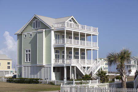
What else is there to say? What do you want to know?
I'm not writing a definitive description of the State of Texas. I'm just hoping to bring up things about the state that writers ought to know, and point them in the direction of a little research that ought to be done.


No comments:
Post a Comment